G'day Everyone! Welcome to TasTrekker. I'm super keen on getting into the Tasmanian wilderness whenever possible. It's a privilege to live and work in this bushwalking paradise. I hope you enjoy reading about exploits past and present.
Saturday, December 19, 2020
Southern Ranges - Take Two - December 2019
Tuesday, July 14, 2020
PCT and Reynolds Falls
PCT is frequently underestimated and underrated. At 80 kilometres it is a similar distance to the OT but the vertical gain is much greater on the PCT - 3,600 metres as opposed to OT's 1,600. Like the OT, PCT has optional side trips to nearby mountain peaks however, PCT's optional side trip to Reynolds Falls features a whopping 850 metre descent where what goes down...
One of Tasmania's responses to this year's Coronavirus pandemic was to shut down all state government managed parks. When a date was finally announced for the reopening of parks for multi-day walks Kylie and I booked seven days off work and mulled over the multitude of walks on offer. Having both run the OT in a day, we are keen to have a go at PCT. The much greater vertical gain makes it a serious undertaking but 4 road access points along the way make for great opportunities to break up the run. The only problem was that we heard floods in 2016 had seriously damaged the track and neither of us had walked the section in the middle of the Leven Canyon which had suffered the greatest impact. A post-pandemic* PCT reconnaissance mission was the way to go.
Loongana, just above Leven Canyon, was forecast to have 51 millimetres of rain on our chosen departure day. I also had some unfinished work so we designated Day One to be a travel day. 80 kilometres up the road we stopped for a couple of hours beside Oatlands' Lake Dulverton for some quality laptop time to polish off some work commitments while Kylie explored nearby sandstone outcrops. We also made the decision to skip the Dial Range section of the track so we could be in the gorge when the likely minor flood peak surged down the most spectacular part of its journey to the sea.
Day Two
 |
| Kylie setting out from Gunns Plains |
Gunns Plains is a broad, limestone-bottomed section of the Leven Valley which belies the deep, narrow and convoluted valleys both up and down stream. After camping in the plains we set out by torchlight 30 minutes before dawn. The trail starts by climbing steeply to a point 100 metres above the river to avoid the Northern Gates, cliffs which guard the river's exit from the Leven Canyon. This would be the first of many ups and downs to be encountered in our day-long journey through the Canyon.
 |
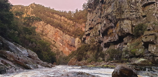
| Northern Gates where the Leven River leaves the canyon at Gunns Plains |

| Watching sunrise from Leven Canyon's Northern Gates |
As we passed a rapid which ended in a classic wave train the water-level seemed perfect for rafts or kayaks but we had the gorge to ourselves. It would be two more days before we saw another human being at close quarters.
 |
| Beach near Tulip Tree Creek, Leven Canyon |
Just after Tulip Tree Creek we traversed what was described in John Chapman's guidebook as, "...the most dangerous part of the route through the canyon..." While it was a bit dicey we found other sections of track to be equally tricky if not more so.
After a while the canyon opens up and Blackwood Camp marks roughly the half-way mark through the gorge. With plenty of daylight remaining we passed the salubriously spacious campsite and continued south. Our progress was soon slowed by a large landslide which had completely obliterated the track. We had to take care walking on steep, loose mud and scree beside the raging river until the trail could be relocated 200 metres upstream. Soon after that another section of track had us befuddled. The route ahead seemed to impossibly skirt around super slippery cliffs which terminated in deep turbulent pools directly below with nothing to break a slide or fall. Halfway along this obstacle we bailed and clambered up into the thick scrub above the river. The terrain was still super steep but at least there was vegetation, albeit it mostly rotten, between us and the raging torrent below. Finally we carefully down-climbed through ferns, decomposing trees, moss and mud and regained river level only to find another steep climb which, this time, was facilitated by a huge fixed rope.
 |
| Kylie checks the logbook at Blackwood Camp, mid-way through the Canyon |
 |
| A landslide makes progress difficult |
Our next challenge was the ascent of Griffiths Ridge, the eastern extremity of Loongana Range. Two thirds of the way up we ditched our packs and took a detour and lost 200 metres of hard-fought altitude descending into the deepest, steepest and most spectacular part of the canyon. This is the only way to see the magnificent double-tiered Leven River Falls which were absolutely pumping - we had timed our arrival with peak flow stemming from the previous day's rain. Far above our heads, tourists popping out onto Cruikshanks Lookout would have been enjoying the spectacle on this sunny, blue-skied day but little did they know this stunning waterfall was thundering 300 metres below their precarious perch.
 |
| Leven River Falls |
Surprisingly our scramble back up to the packs was faster than the descent. The side-trip had taken exactly an hour and we had limited daylight remaining - an issue which was to haunt us a few days later. At the top of the ridge we paused briefly for the view before descending back into the gorge and meeting the river again, this time on a spectacular bend above the falls. The final remnants of daylight were just enough to descend some fixed ladders and seek out a level tent spot deep in the gorge.
* Post-pandemic: I may be counting chickens before they hatch. However, at the time owriting, it has been 52 days since the last recorded case here. Our watery border (our "moat" as described in one local newspaper) has been effectively closed for more than three months.
Day Three
A slightly slower start was in order so we could appreciate this section of the river in daylight. Right on dawn we finished packing and took our time along the next section of river. Firstly a fixed set of steel steps gained us a lofty perch overlooking the seething rapids on the bend which are fed by spectular narrow sections of gorge, again, not a place to slip.
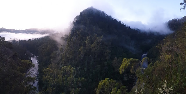
Geologically this section of the river is young having been diverted from the other side of the hill by a massive landslide which took a huge chunk out of Griffiths Ridge. The river, therefore, has not had a chance to carve a broad path. This is displayed most sensationally at the Leven Splits where a steel bridge spans a ridiculously narrow gap and brings a short, steep side-path down from the nearby Loongana Road. Without needing to cross at this point, the PCT continues along the north bank.
 |
| Leven Splits looking upstream |
 |
| ...and looking downstream |
At morning tea time we arrived at the Loongana campsite which could have been reached in a long day from Gunns Plains had more daylight been available - maybe next time. From here the trail loses some of its wilderness feel as lush, green farmland lines the opposite riverbank while the river itself takes on a lazy meandering feel in stark contrast to the raging torrent just a few minute's walk downstream. As we briefly left the river the track became engulfed in bracken heaven where perfect growing conditions allowed fronds to consistently reach 2 metres high in places. A short, steep section then allowed to skirt then traverse a section of private property before crossing a stile onto Loongana Road where we saw precisely zero cars on the two-kilometre road-bash through to Taylor's Flats.
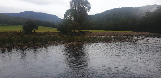 |
| Black Bluff and the Leven River at Loongana |
Just over the river from Mountain Valley Cabins we said goodbye to the Leven River for the last time as we started the consitent climb out of the valley via Brookes Track gaining 700 metres height over the next three kilometres. This direct route* onto the mountain is rewarded with a stunning campsite on Paddys Lake cradled below the craggy summit of Black Bluff. After setting up camp and enjoying a quick side trip to the decaying steel-framed trig point on the bluff we were treated to incredible evening entertainment as our lofty perch provided a perfect view of the winter-solstice sun setting below a clear sky while at our feet the north-west coast lay mostly hidden below low cloud.
* There is a longer, less direct but more varied route via Jean Brook, Smiths Plains the historic Tramway Track and Winterbrook Falls but it is a long detour and would require an extra half a day or so to complete - an adventure for another time.
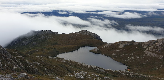 |
| Paddys Lake |
 |
| Evening light on Black Bluff |
 |
| Sunset at Paddys Lake |
Day Four
Time for a pre-dawn start again! 30 minutes was all we needed to scoot over the ridge, past the 4-way junction where the Winterbrook Falls and Black Bluff sidetrips meet PCT and on to the substantial stream crossing a few hundred metres above the falls. Kylie provided the perfect shutter fodder as she nimbly crossed the slippery rocks silhouetted by the gorgeous sun rising in front of Mount Roland to the east.
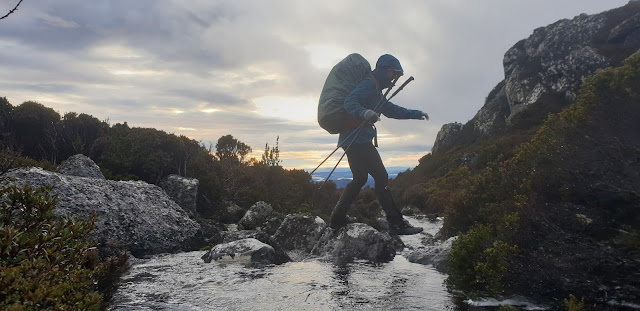 |
| Kylie crossing Winterbrook on Black Bluff's eastern flank at sunrise |
Our day's mission was to traverse the full-length of the Black Bluff Range to the campsite at Fourways, some 20km south as the crow flies. Once again, clear skies delighted us as we reveled in the views of mountains ranging from Western Bluff to Cradle Mountain, the distant Pelions, Tyndall, Meredith and Norfolk Ranges around to the closer peaks such as Pearce, Cattley and Tor. On one side of the range we had the romantically-named Vale of Belvoir to keep us company where the bi-directional drainage and above-ground karst features indicate the limestone which underlies the mostly treeless sub-alpine vegetation. Lake Lea, the meandering Vale River and a myriad of tarns add to the visual delight in that direction. On the other side the view is now dominated by massive tree farms which occupy an area originally intended for sheep production by the Van Diemens Land Company in the early 1800s. Well before that ill-fated agri-business decision the first Tasmanian's for countless generations would have fired these plains and enjoyed the wildlife bounty that followed new growth stimulated by the regular burns.
 |
| Not Duff Creek with Mount Ossa (behind the bush) and Cradle Mountain |
Midway along the range we passed the Bare Mountain Camp which could provide shelter from the westerlies which would howl mercilessly over the range much of the time. On this occasion a keen south-easterly was blowing straight up the shallow valley so we lingered not, instead lunching in the westerly lee of some low shrubs. Barely a tree is passed along the entire length of the range so this could be an exposed and miserable traverse in bad conditions.
At Prospect Mountain we had a double treat in store. Firstly we met the only other walkers we would see in our entire 6-days on track. These gentlemen from Hobart bore news of crazy rain. Apparently Hobart was being drenched with kunanyi Mount Wellington recording it's highest 3-day rain tally on record. This news made our 3-days of clear skies and sunshine all the more special. It also explained why we never had clear views to the South East - the other 270º had been mostly could free but not once did we see the mountains in the south-easterly quadrant.
The other treat was a throwback to the history of my home town. Henry Hellyer is generally accepted as the founder of Burnie in 1827. Ironically, he went against orders and established road and port infrastructre on Emu Bay when his boss preferred the Inglis River at what was to eventually become Wynyard. While surveying the would be sheep grazing districts south of Burnie, Hellyer erected a stone cairn on Prospect Mountain which can still be seen today. I was unsure of its exact location and it is not visible from the track so a little scouting around was needed. It was Kylie who first spotted it after a very short search so I proudly posed with that little bit of home-town history.
 |
| Posing with Henry Hellyer's cairn |
After crossing the Belvoir Road, Mount Beecroft took a frustratingly long while to get closer to the point where we could not contemplate the Abel-bagging side trip - once again, another time! Instead we scooted past and enjoyed the spectacle of the Fleece Creek waterfalls being lit by the setting sun as we attempted to stay on our feet for the incredibly slippery descent off the range. Since leaving Paddys Lake we had encountered cushion plants communities with hardly any evidence of disturbance, muddy bogs, close-knit scoparia, ankle-high alpine meadows, clumpy button grass and even a few sections where recent track work had cleared a metre-wide superhighway.
Our arrival at Fourways was perfectly timed with the fading light just enough to pitch the tent and collect water from a disturbingly swift Vale River.
 |
| Approaching Mount Beecroft in the late afternoon light |
 |
| Sunset at Fourways Camp |
Day Five
Another early start had us crossing the Vale River by torchlight - not the time to be venturing the short distance downstream to the waterfall coined as, "Indescribably beatiful" by one visitor in the early 1800s. As we climbed beside Fleece Creek first light lit the distant ridges protruding into the depths of the Vale River gorge beyond Mount Beecroft. Hopefully later in the day we would be in those depths to visit Reynolds Falls.
We soon passed a lovely copse of Pandanis but 20 minutes later a sign indicated we had not reached Pandani Grove as early as we thought. Just before crossing Fleece Creek we briefly headed off track through open myrtle forest in a bid to cut the corner and reach the Reynolds Falls Track sooner but quickly decided discretion was the better part of valour and rejoined the PCT. Above Fleece Creek we finally reached the old 4WD track that we would follow towards Reynolds Falls. We followed this to the confluence of Marsden and Fleece Creeks. This is a good place to camp so, at 9:00am we swapped our big packs for day bags and set out for Reynolds Falls. We had 8 hours of daylight at our disposal and John Chapman reckons it's a 9-hour side trip from the PCT - what could possibly go wrong?!? Well...
Progress along the 4WD track was easy for about 30 minutes. As we approached Pandani Creek a few annoying minutes were lost trying to find the correct route where bauera was winning a campaign to eliminate the track. Once over the creek delightful myrtle forest made for easy going before passing several family-like pandani groves and finishing up on a gently-sloping coral fern plain. At this point the track disappears completely. A few old snow poles and markers indicate the track follows the southern edge of the plain but is then lost in light forest before you suddenly arrive at what I'd call the first plunge. Here the hillside drops dramatically and it is important to find the point where the track starts a 200 metre descent through deep, dark myrtle forest.
A delightful waterfall (we called this Not Tumbling Creek) is crossed before sidling briefly and descending another 100 metres to cross the real Tumbling Creek. Sunshine filtering into the steep valley was drawing illuminated plumes of mist from the mossy rocks but we could not pause for long. We were one third of the way through our available daylight but only half-way to the falls. After leaving the creek we soon found ourselves without markers. I pressed on, clearly remembering from my previous trips that the Tumbling Campsite was on top of the ridge and not far away. When we reached the obvious top of the spur there was no sign of the campsite or track. It was time for a break and, sadly, time to call the day's mission to a halt.
After a short lunch break we checked the map and could see the track passed through a very shallow saddle back from the high point we had reached. Sure enough, 3 minutes later we were at Tumbling Camp with the taped route leading away in both directions. Buoyed by being back on track we hatched a plan to return to our packs and try again the following day. Heading back to Tumbling Creek we found the error of our ways. A massive, lone delegatensis tree had fallen and obliterated the track for quite some distance right where it makes a switchback that is not marked on the map. In fact there are many places where the track on the map is only a rough representation of the track on the ground.
Back at our packs conditions were still fine and dry with no sign of the forecast rain that was due to arrive overnight. It was great to set up the tent in a leisurely fashion instead of being somewhere between there and the falls and stressing about finding the 4WD track before dark.
Day Six
As promised, the following morning dawned soggy but that is most appropriate for a waterfall mission. Smack on 7:00am we set out and, as the sun was rising somewhere beyond the rain clouds, 30 minutes later we left the 4WD track. The bit before the plunge posed a navigational challenge for the third time in two days but we were stoked to arrive at Tumbling Camp for morning tea at 0915am - a big improvement on the previous day's 11:45.
From Tumbling Camp the myrtle continues and the track does not stray far from the 700 metre contour before a second plunge drops 200 metres even more steeply than the first plunge way back at the start of the myrtles. The sound of a stream accompanied our descent until we finally crossed it to arrive at the best looking campsite of the track. This would be a good option for a multi-day walk but it's a big commitment to carry overnight gear this deep into the valley. What goes down...
 |
| Reynolds Camp |
The third plunge loses the final 200 metres to the falls and this is where the forest has a subtle change in character. While the understory is still dominated by moss and rainforest plants, the myrtles are suddenly replaced by giant eucalyptus delegatensis trees. This is a great place to appreciate the arm wrestle which takes place right across Tasmania between the fire-loving eucalypts and the rain-loving myrtles. It is incredible how the desert-continent-bred eucalyptus family has come up with a handful of species that can match it with the rainforest, surviving many centuries without fire and growing into some of the tallest trees on the planet. I wonder what the next few centuries will have in store for this particular hillside. Will the last remaining dele gums tumble, ceding victory to the myrtles? OR Will fire eventually sneak into the mossy depths and breathe reproductive life into the eucs so they can win the duel? Only time and, sadly climate change, will tell. I digress!
The trail delivers walkers to a bend some 100 metres below the falls. On previous visits I've scrambled and waded upstream to a ridge much closer to the falls. On this visit we had a strong desire to avoid flirting with dark so we soaked up the view from the bend. It is a magnificent sight. The classic single drop leaps 50 metres from a narrow notch in the cliff. After many oohs, ahhs and the obligatory happy snaps we wended our way back to our tent with 30 minutes of good daylight to spare.
 |
| Reynolds Falls |
Day Seven
On our final morning it was exciting to wake and find a light dusting of snow had settled overnight. After all our dawn or pre-dawn starts it was lovely to have a super-relaxed 9:30am departure. While light snow fell intermittently on our walk over the Speeler Plains, conditions were far from extreme. Views extended as far as Quailes Hill, Mount Kate, Hounslow Heath and up the Pencil Pine Valley. However, Cradle with its accompanying peaks and ridges was staying hidden. Not to worry - our trip had been a corker. Snow on the last day was icing on the cake and brooding overcast skies were part of the deal.
After drying out by the fire at the Interpretation Centre we had a thoroughly enjoyable lunch at the lodge with my parents. They then kindly delivered us back to our car at Gunns Plains some 90 minutes drive away via Moina, Wilmot and the Valley of the Shadow (aka Spellmans Bridge - I think it's only my dad and his mates who called this the Valley of the Shadow).
What a week! Sunshine, snow, waterfalls, mountains, gorges, blue skies, sunsets, fungi, rainforest, history, giant trees, sunrises and we essentially had the whole place to ourselves.
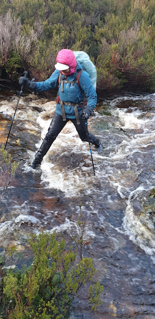 |
| Kylie crossing Fleece Creek |
 |
| Speeler Plains |


