It's official... Blogger is driving me nuts! Uploading pictures is an absolute nightmare. This process seems to work 1 in 10 times. Also, the speed of the site is terrible.
I expect all of this is due to Blogger being in the US and me being in little old Tassie.
Anyway, I've found a great Australian blog site called whitepage (not to be confused with the telephone directory people!)
Edit: The whitepage people got gezumped by the phone directory people. It was deemed that the names were too similar.
Check out my new blog at http://www.blognow.com.au/tastrekker.
Tuesday, May 23, 2006
Monday, May 22, 2006
Hydro Hut

Last year, a friend told me about an out of the way hut on the eastern Windermere Plains known simply as The Hydro Hut. His instructions sounded inviting: “A couple of hours walk from the Overland Track, over a ridge and down beside a tarn.”
As the crow flies, the hut is only 2 kilometres from the old Wolfram Mine in the Forth Valley. However, the road to the mine has been closed 30 kilometres to the north near the Lemonthyme Power Station. There is also the matter of the hut being 700 metres higher than the mine below.
So… To find this hut, there are 2 choices: (1) A 30 kilometre road bash (walking or mountain bike) from the power station to the mine then a very steep climb through dense bush to the plains 700 metres above. OR (2) Approaching from the Overland Track via a long walk in from Cradle Valley.
To add to my interest, a 1919 geological map of the area shows a track zig-zagging up ‘The Razorback’ beside Commonwealth Creek. Perhaps it would be possible to locate this to assist with the climb from the valley.
Given the uncertainty of the road conditions I decided to take the long walk from Cradle Valley. As always, with a young family and full-time work commitments, time was at a premium. Half a weekend was available. At more than 50km much of which would be untracked, a day walk was a bit too much. Therefore a Friday night and Saturday walk was the best option.
Teamed up with a mate from work, we set out from Dove Lake at 5:30pm on a mild November Friday afternoon. Marions Lookout and the Plateau were dispensed with before sidling between Cradle Mountain and Fury Gorge to the Cirques.
The sun went down as we descended to Waterfall Valley Hut for a break. To minimise the walking needed tomorrow, we decided to leave the comfort of the hut and use the dim light of dusk to push further towards our goal.
Once we passed Barn Bluff in the gloom, by 9:00pm we arrived at our campsite beside a small lake on the open and exposed Windermere Plains. During the next hour, we pitched the tent then cooked and devoured a hearty meal. While eating, an ominous inky black cloud was devouring the western horizon. Frequent lightning flashes lit the mountain ranges as they were gobbled up by the approaching storm.
With dinner done and gear away, just as the last tent zip was closed, the storm hit. Lightning flashed, thunder rolled, heavy rain and gale force winds shook the tent. A weather station on nearby Mount Reid recorded winds gusting up to 180kph as the front went through. With warm sleeping bags and a robust tent, it was exciting to be so close to the storm’s fury yet so warm and dry.
The following morning was mostly sunny with a few cloudy patches. A brief snow shower accompanied us at 7:30am as we headed away from the security of the Overland Track into the untracked beauty of the eastern Windermere Plains. A distant ridge marked our goal and we started to make a beeline for it.

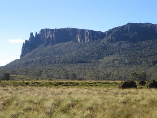
Barn Bluff soon after we left camp to wander the untracked wildflower carpet of Windermere Plains.
After walking for a short while, a pretty cliff-lined gorge was negotiated upstream from Lake Agnew. We launched ourselves over the swollen creek without incident and progress continued steadily beside tarns until the target ridge was reached. Some rock hopping along the ridge avoided the worst of the scrub until the most westerly peak was mounted, revealing the remote hut below perched on the edge of a small tarn.

The Hydro Hut from the west.
After leaving the hut, we visited the nearby rim of the plateau. First, we looked south over a waterfall to the rainforest-bound confluence of Douglas Creek and the Forth River. A little further around the plateau, we looked down to the Wolfram Mine close below to the east. The open areas of mine tailings and gravel I visited as a child 24 years ago appear to be quickly being reclaimed by the forest.

Douglas and Forth valleys with Mts Oakleigh, Pelion East, Ossa, Thetis and Pelion West.
After lunch by the lake shore, we looked for a spot to recross Commonwealth Creek and found a large squared log with a big rusting square peg driven through it. The old mining map later confirmed that the Razorback Track crossed at this point on its way from the Barn Bluff mines below Lake McRae to the mines above Lake Windermere. Perhaps our log was the remains of an old bridge.
Once we regained the ridge above Lake McRae, we retraced our steps back to camp, packed up the tent and wandered back along the Overland Track. This was the first week of the new permit system where walkers are all required to walk north-south. We were therefore going against the flow and attracting a lot of funny comments.
One German walker said we were going the wrong way. I responded saying that we only did a short walk. He laughed and said we had a lot of gear for a short walk. Hmmm… It’s funny how a pack with tent, stove and sleeping bag looks and feels much the same for a 1 night walk as it does for 5 nights. Oh well. That’s just one of those things.
We arrived back at Dove Lake just on 7:30pm after 26 delightful hours in the Tasmanian bush.
Tuesday, May 09, 2006
February Plains
2 weeks ago on ANZAC Day, Tuesday 25th April, I dashed up into the Mersey Forth high country for an afternoon exploring around the north end of February Plains.
I was inspired by Ned Terry’s book “Identities and History of Tasmania’s High Country.” Several of the trappers, snarers and stockmen spoke about “the February.”
February Plains average about 1100 metres above sea level and can be a very inhospitable place during the winter months. They lie along the flat-topped ridge that runs north south between the Mersey and Forth River valleys. In the north, they rise above Borradaile and Emu Plains, south of Mount Claude. In the south, February Plains come to an abrupt end at the cliffs of Mount Oakleigh.
I approached from the north along logging roads over Bare Hill and Borradaile Plains. A few years ago, the Cradle Mountain Lake St Clair National Park and World Heritage area boundary was moved north to include February Plains and to protect the dense forest of the Lemonthyme Valley.
After leaving the car at a locked gate, I walked south along the disused logging road before heading up onto the button grass plains on top of the ridge. After an hour walking, a large coil of rusty wire hanging from a tree served as the first reminder of times past when mountain cattlemen would bring stock up here in the summer months.
Tucked among the trees on the northern end of the plains, I visited the decaying remains of a snarers hut. The roof had gone and three walls were nothing more than an open frame. The one standing wall still had chicken wire over the open eaves where smoke used to escape from the fire used to dry the possum and wallaby skins.
From the high parts of the plains Cradle Mountain, Barn Bluff and the surrounding ridges could be seen to the west sporting a thick coat of fresh snow. At one point, Mount Pelion West also showed its snowy head. In the east, the peaks lining the western rim of the central plateau glowed in the sinking sun.
I completed my circuit by following Sardine Creek back to the disused logging road a few kilometres south from where I started. As I approached my car, the sun set right behind the Cradle Mountain massif creating a stunning silhouette to cap off a pleasant afternoon.
I was inspired by Ned Terry’s book “Identities and History of Tasmania’s High Country.” Several of the trappers, snarers and stockmen spoke about “the February.”
February Plains average about 1100 metres above sea level and can be a very inhospitable place during the winter months. They lie along the flat-topped ridge that runs north south between the Mersey and Forth River valleys. In the north, they rise above Borradaile and Emu Plains, south of Mount Claude. In the south, February Plains come to an abrupt end at the cliffs of Mount Oakleigh.

I approached from the north along logging roads over Bare Hill and Borradaile Plains. A few years ago, the Cradle Mountain Lake St Clair National Park and World Heritage area boundary was moved north to include February Plains and to protect the dense forest of the Lemonthyme Valley.
After leaving the car at a locked gate, I walked south along the disused logging road before heading up onto the button grass plains on top of the ridge. After an hour walking, a large coil of rusty wire hanging from a tree served as the first reminder of times past when mountain cattlemen would bring stock up here in the summer months.
Tucked among the trees on the northern end of the plains, I visited the decaying remains of a snarers hut. The roof had gone and three walls were nothing more than an open frame. The one standing wall still had chicken wire over the open eaves where smoke used to escape from the fire used to dry the possum and wallaby skins.
From the high parts of the plains Cradle Mountain, Barn Bluff and the surrounding ridges could be seen to the west sporting a thick coat of fresh snow. At one point, Mount Pelion West also showed its snowy head. In the east, the peaks lining the western rim of the central plateau glowed in the sinking sun.
I completed my circuit by following Sardine Creek back to the disused logging road a few kilometres south from where I started. As I approached my car, the sun set right behind the Cradle Mountain massif creating a stunning silhouette to cap off a pleasant afternoon.
Thursday, May 04, 2006
Mount Pelion West

Here goes! My first attempt at blogging.
Normally I would avoid computers like the plague outside of work but blogging seems to be all the rage and I have a bucket load of Tassie trekking tales to tell.
I am passionately proud of this island state, Tasmania. I grew up on the north west coast and the world heritage wilderness surrounding Cradle Mountain was my back yard.
Now I have moved to another part of the island where I am IT Manager for a factory owned by a large US-based multi-national company.
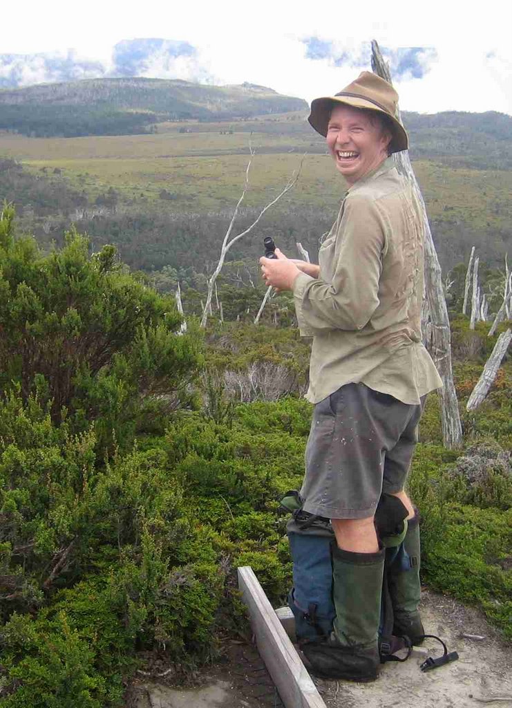
The first trek/bushwalk/ramble I want to describe was a trip to Tassie’s 3rd highest peak, Mount Pelion West. The following text and pictures are from an article I have just written for our company magazine…
Tasmania is one of the most mountainous islands in the world. A book called “The Abels” lists 155 mountains over 1,100 metres above sea level. When the IT Manager (tastrekker: that’s me) and Chemical Research and Development Manager (tastrekker: my walking companion on this trip) looked for a mountain to climb earlier this year, there were plenty to chose from.
tastrekker tells the story…
The chosen candidate was Tassie’s 3rd highest peak, Mount Pelion West at 1,560 metres above sea level. The highest mountain, Mt Ossa is climbed by many people who walk the Overland track and we had both ‘been there, done that!’. The second highest, Legges Tor has a road up it with the Ben Lomond ski village perched on top - not much challenge there!
We approached our objective from Arm River in the Mersey Valley on Saturday 4th March. As a warm-up, Mt Pillinger (1285 metres) was climbed after a steep ascent from the car park. The views were stunning with clear sky and dozens of mountains in every direction. Tarns and Lakes on February Plains sparkled to the north while the upper Mersey River meandered its way through the native grasslands of Lees Paddocks. 600 metres below our sublime lunch-spot, every shade of green imaginable was present in the rain forest lining Wurragarra Creek.
From Pillinger, a gradual descent took us down to the shores of Lake Ayr where we met the Overland Track at Pelion Hut. In the past, anything up to several hundred campers could be found in and around Pelion Hut on a fine summer night. A new permit and fee system limiting the number of walkers during the peak season has made such overcrowding a thing of the past. On this balmy afternoon, a mere 30 to 40 walkers were making this their accommodation for the night.
While the ‘luxury’ of Pelion Hut was tempting, Pelion West beckoned. If we were to make it back to the car the next day, a little more progress would be needed before stopping for the night.
An hour north along the Overland track brought us to Frog Flats where the infant Forth River lazily trickled by our grassy campsite.
Next morning, with breakfast dispensed with, we left the tent to dry and set out towards our goal. The gradual climb through rainforest revealed occasional glimpses of low cloud filling the valley. Pelion West brooded silently above us. Even after climbing above the tree line, the clouds only briefly parted to reveal the cliffs surrounding the base of the mountain.
Upward, ever upward, the climb continued over house-sized boulders precariously perched atop towering cliffs. Careful route selection was needed to avoid the cavernous gaps in between.

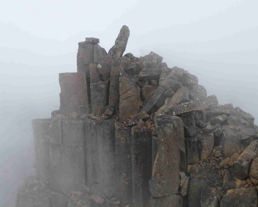
Finally, the summit was reached. A finger of rock jutting skyward from the edge of a south-facing precipice marked the highest point. Any concern about heights had to be ignored to climb the obelisk beside a 250 metre drop to the scree below.
The cloud came and went during our summit stay. Views opened up in most directions with peaks from Cradle Mountain to Frenchmans Cap and Mount Murchison to the Walls of Jerusalem presenting themselves in turn. The Overland Track could be seen, threading its way to the north between the tarns of Windermere Plains.
Bushwalking in Tassie is a great past time. This walk was a little on the ardous side with 50km covered in 2 days and 1,500 metres vertical climb. The good news is there are many walks to choose from for every level of ability where spectacular scenery and a sense of isolation can be achieved. If you have never tried getting into the bush before, it’s never too late to have a go!
Subscribe to:
Posts (Atom)